

Catherine Akpan
For years, residents around the Tropicana axis of Uyo in Akwa Ibom State had lived with a challenge that turned everyday life into a struggle. When the rains came, the road leading into parts of the community disappeared under muddy water.
Vehicles could barely pass, and in some places even walking became difficult. Only about 500 metres of the route was accessible, leaving the rest of the area almost completely cut off.
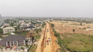
Investigation by Straightnews online reveals that today, however, the story of that once-neglected stretch is changing. Heavy equipment now rumble across the landscape as engineers work steadily on the Ibom Tropicana Internal Roads Project, a strategic infrastructure initiative designed to restore access and improve mobility in the area.
For Rose Chinyere Orji, an administrator at a school in the area, those memories remain vivid. She recalls that when the school began operations in 2016, many pupils came from the Shelter Afrique area, but parents often worried about the condition of the road. According to her, during the rainy season movement became extremely difficult, and accessing the school was sometimes nearly impossible.
”Parents struggled to drop off their children, businesses received fewer customers, and residents often had to navigate muddy paths just to reach the main road. The terrain was uneven in places and severely waterlogged in others, creating a daily challenge for those who lived and worked in the neighbourhood,” she stated.
In an interview, Surveyor Enobong Umoh, Assistant Chief Surveyor, Hensek Integrated Services, said ‘‘The project spans approximately 3.5 kilometres, connecting Afaha Ikot Obio Nkan to Ring Road 3, with an additional spur through Akpan Aduk. Located within one of Uyo’s fastest-growing commercial and hospitality districts, home to the Ibom International Hotel, the Ibom International Convention Centre, and the developing ARISE Shopping City, the road network is opening up a once-difficult-to-access part of the city.
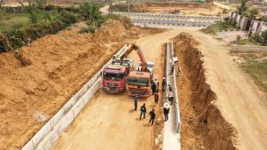
‘‘The road is designed with an eight-metre-wide carriageway and double-sided drainage channels measuring 800 millimetres by 800 millimetres. Engineers on the site explain that the drainage system is a combination of both underground and surface drains, carefully constructed to address the area’s long-standing flooding challenges.
”At its deepest section, the underground drainage reaches approximately five metres below ground level. The system is designed with a sloped alignment to ensure efficient water flow toward a designated discharge point behind the defence line, effectively eliminating the perennial flooding that previously plagued the community.
By reducing erosion, waterlogging, and stagnant water, the drainage infrastructure is also expected to improve sanitation and public health conditions within the area.’’
For residents who have endured years of flooded roads and muddy paths, the sight of these massive drainage channels being constructed offers reassurance that the future will be different.
When completed, the project will provide a fully motorable internal road network, improving both pedestrian and vehicular safety while enhancing access to homes, businesses, and institutions within the neighbourhood.
Among the direct beneficiaries will be institutions such as the Girls British International School, whose accessibility is expected to improve significantly once the road is completed. Businesses within the area are also expected to benefit from increased customer access, while property values around the neighbourhood are projected to rise as infrastructure improves.
Beyond improving mobility, the project is already generating economic activity within the community. More than three hundred workers are currently engaged directly and indirectly on the construction site, including engineers, equipment operators, artisans, suppliers, and labourers. The project is therefore providing income support for hundreds of households while also exposing young workers to valuable skills in surveying and civil engineering.
Analysts believe that local suppliers, food vendors, and small-scale traders are also benefiting from the increased activity generated by the construction work.
For community member Idongesit Ene, ”the impact is already visible. He notes that many people from the community are now working on the project, adding that the employment opportunities have provided a significant boost for local residents.
Equally noteworthy is the strong cooperation between the host community and the construction team. Residents say the project has enjoyed peaceful support from the community, allowing work to progress steadily without disputes or disruptions. This spirit of collaboration has helped ensure that construction continues smoothly.”
The road project forms part of the broader infrastructure development drive of the Governor Umo Eno–led administration, whose focus on improving road connectivity continues to open up communities and stimulate economic growth across the state.
It is discovered that when completed, the Tropicana Internal Roads Project is expected to ease traffic congestion around Ring Road 3, create alternative access routes linking Afaha Ikot Obio Nkan, Nkereuwem Udo, Akpan Aduk, and surrounding neighbourhoods, and facilitate faster movement of goods and services within the Tropicana axis.
But beyond engineering statistics and construction timelines, the impact of the road is deeply human.
For residents who once struggled with flooded paths and impassable routes, the project represents something far more meaningful: easier access to schools, better opportunities for businesses, safer roads for pedestrians and motorists, and renewed confidence in the power of infrastructure to transform communities.
For the people of the Tropicana axis, the road is not just changing the landscape. It is changing everyday life.