

Israel Umoh
Our trip to Amasiri Community in Ebonyi State began under early morning drizzle and marked by heavy rainfall in Uyo, Akwa Ibom capital.
Uyo is a fast developing town, but heavy flooding is one of its challenges. Once it rains, some streets are impassable while passersby and motorists are not spared the angst of ferocious flooding.
On Friday, June 26, we set sail in two buses to the agrarian community called Ogo Ogweuhie Amaebo Ohachara in Amasiri Afikpo Local Government Area of Ebonyi State. Without driving, I decided to stroll to pick a motorcycle or Keke ride to 12 Urua Udofia Street, Uyo for a funeral service in honour of the octogenarian Chief Chukwu Azu Chukwu, father of Pastor Sunday, the Regional Overseer of Mountain of Fire and Miracles Ministries, South South 33 Region, Uyo, Àkwa Ibom State.
Before 6 a.m, the sky was dark and cumulonimbus cloud hovered over the area. Shortly, the sky let loose and the streets and roads were heavily flooded. From High Tension to Udo Ekpo Mkpo Street, Eniong Offot in Uyo, flood took over and sent road users- Keke operators and motorists – packing.
Also read: Christmas Bonus: Ebonyi Governor Dashes Civil Servants N150,000
It was messy trekking from the street to Nwaniba Road to board a bus or a Keke. By the time I arrived at the take-off point, I had been soaked. The little umbrella could not cover me well.
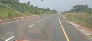
Exact 7 a.m. we zoomed off from Uyo through Ikot Ekpene detouring through Umuahia Road to Ikono and Ini Local Government Areas. Rainwater still flooded Ikono road and parts of Ini.
From Ikpe Ikot Nkon in Ini, the road was dry, showing that there was no rainfall in the area. Our bus sped through the road – Iwerre, Nkana and Obotme. The road was smooth. Thick farmlands filled with oil palm trees stretched both sides of the road. It is not a make-believe that Àkwa Ibom sits on agrarian belt. Farmers from the area were seen popping out ceaselessly like rodents from the bush tracks with farm products- cassava and palm fruits, among others to the main road.
Another remarkable scene of the road is the murky-look Kwa Iboe River that runs beneath a major bridge on the 14.1 km Odoro Ikpe–Ikpe Ikot Nkon–Obotme–Arochukwu Road, which serves as a vital economic link between Akwa Ibom and Abia states. But an edge of the bridge has been mercilessly eaten by soil erosion.
Not long, we drove to a small bridge with a telling message: Welcome to Ozu Abam. As elementary geographers, we knew that we have landed in Abia State. The driver throttled speedily and rammed into a well-paved but macadamised road. Thoroughly constructed, and properly demarcated with white-yellow paints with pedestrian bumps where necessary, drivers sped past all.
The reconstructed Ozu Abam–Ndi Okereke–Arochukwu Road in Arochukwu Local Government Area of Abia was awarded and executed by Abia State Government under Alex Otti administration. The construction was officially flagged off in early 2025, alongside the new Omenuko Bridge project.
The 30-kilometre road and the new Omenuko Bridge were inaugurated in February 2026 after completion.
From there, our driver veered into another reconstructed Arochukwu-Ohafia Road. The road is a 41.4-kilometer that stretches from the Ohafia axis through such rural communities as Ihechiowa, Ututu, and Isu, connecting Arochukwu and neighbouring states.
Smooth and well-demarcated, the road is another beauty to behold, courtesy of pragmatic and resilient Governor Otti. During the Abia ex-Governors Theodore Orji and Okezie Ikpeazu administrations, the road was in a decrepit state, forcing motorists to abandon it and went for diversion.
Passing through Ohafia reminded me of Rev. Dr. Uma Ukpai who died in October last year but was buried in his hometown – Asaga in Ohafia Local Government Area of Abia State on March 27, this year. Ukpai was a televangelist, preacher, teacher and miracle maestro who had lived in Uyo more than 50 years for missionary exploits. His passage into eternity took many especially his members, mentees and admirers by surprise.
Detouring from Ohafia Road to Edda in Ebonyi was another experience. The entrance to the road was rickety and lonely too with patches of bush and cashew trees on both sides of the road.
Most major roads in Ebonyi State are built on concrete owing to the porous but watery topography of the area.
Heading toward Amasiri were dizzying ravines and deep gullies by the side in Ogwuma. Located in the Umunna Autonomous Community of Afikpo South Local Government Area (often referred to as Edda), the village is built on highly volatile, hilly terrain. The community has faced severe ecological disasters, where massive landslides and deep gully erosion have created terrifying and dizzying ravines that have swallowed homes, economic trees, and major roadway.
Some of roads were a ghost of themselves as modern buildings and thatched houses adorn them. What a clash of riches and poverty!
The most common and valuable economic trees in Ebonyi State are oil palm, bush mango (Ogbono), cashew, and mango.
While Ebonyi State is famous for its massive production of staple crops like Abakaliki rice and yams, its tropical climate and fertile soil support a wide range of economic trees.
One remarkable landmark infrastructure is called the Vanco Flyover. It is officially located at the Vincent Agwu Nwankwo Junction (commonly referred to as Vanco Junction) along the Ogoja Road in Abakaliki, Ebonyi State. It is a modern piece of aesthetic and architectural designs.
After the ceremony, we headed to Uyo. The takeaways from my trip to Amasiri community were enormous for documentation. And the return from the three-hour trip eventually terminated in Uyo about few minutes past 5 p.m. and the bus occupants disembarked to their various destinations.